This is the video we made to address the basic concept of this blog which is 'Traveling'. We took a day in Sydney city and had a few good shots of those beautiful sea and sites and edited it together with a song and show to you guys. Just want you to know that travel can be fun and relax, experiencing new things sometimes can give you joy and someday you are going to look back and remember all the place you have been, doesn't it nice to have some beautiful place stay in your memory? Maybe consider when you want to travel no matter locally or outside of the country. Please enjoy the video! :)
Nicole & Sara :)
2015年5月14日星期四
2015年4月21日星期二
Zhongshan Mountain - Tomb of Sun Zhongshan

Zhongshan Mountain, area of more than 8 million square meters. Zhongshan Mountain start since the spring of 1926 and finished in 1929, in 1961 became the first batch of national key cultural relics protection units, it is also a national key scenic area and national AAAAA level scenic spots.

Zhongshan Mountain is located in the eastern suburbs of Nanjing Zijin Mountain area, the east border Linggu Temple, west of Ming Xiao Mountain, the entire building was built according to the mountain, from south to north along the axis of the main building has gradually increased, the arch, ramps, Mausoleum doors, stone steps, Beiting, the festival hall and tomb, arranged in a central axis China, reflects the traditional architectural style, look down from the air.

A tall granite arch among at the entrance of the tomb, with Sun Zhongshan's hand written "fraternity". From the entrance to the main court has a total of 392 stone steps,represents the Chinese three hundred and ninety-two million people; 8 platform, a symbol of the three people's principles of the five power constitution.
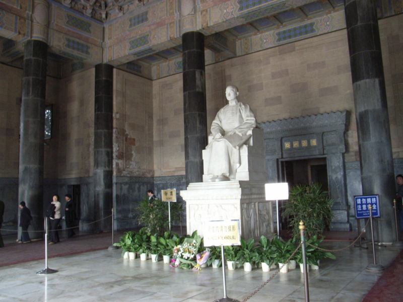
The tomb is build by the blue glazed tile and granite walls. Blue symbolizes the sky, also link to the flag of the Republic of China -- the red ground symbolizes fine day. The blue sky is a symbol of the Chinese nation, lofty personality and ambition.
Opening hours: 7:00-18:00 (exclude Monday)
Ticket price: 90 yuan (including: Zhongshan Mountain, Ming Xiaoling Mausoleum, Linggu Temple)
Reference:http://baike.baidu.com/view/9667.htm
WAJI1D1501 Jiayi(Sara)Wang
2015年4月18日星期六
West lake - water wonderland for centuries


Chinese: 西湖 Xī Hú (xi is 'west'; hu is 'lake')
Location: southwest of downtown Hangzhou, 180 km southwest of Shanghai
Area: 6.5 square kilometers (2½ square miles)
Highlights: The Ten Scenic Sites of West Lake, boat cruises, biking, scenic walks, Impression West Lake night show

Spring (March to May) is the best season for enjoying West Lake. The green leaves and flower blossoms make the lake more beautiful. Thus March and April is the peak season for West Lake travel.
The Best Places to Enjoy Spring at West Lake:
- Su Causeway: When spring comes, the whole causeway is blanketed by peach blossoms and weeping willow catkins, creating an especially charming scene.
- "Viewing Fish and Lotus Fronds at Flower Pond": This classic sight is at the southern end of Su Causeway. It is one of the most famous sights of West Lake, where many people come every day to see and feed the goldfish in the lake.

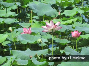
Summer (June to August) is the season of lotus flowers. The lotuses in West Lake attract many people.
- "Lotus in the Breeze at Crooked Courtyard" (a classic West Lake sight) refers to an area by the western shore of West Lake. Every summer, there are hundreds of types of lotus in full bloom, attracting many visitors.
Fall (September to November) is very cool at West Lake. The weather is less rainy, which makes it a good season to appreciate the beautiful moonlight at night. West Lake is a popular place to enjoy the Mid-Autumn Festival full moon.
The Best Place to Enjoy Fall at West Lake:
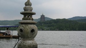
- "Three Pools Mirroring the Moon" is perhaps the most famous of West Lake's classic sights. Its image is printed on the one yuan bank note. On the night of the Mid-Autumn Festival, when the moon shines full and bright in the sky, a candle is lit inside each of the three mini pagodas on the water. The light from the pagoda windows and the moon cast their reflections on the water, hence the name.
Winter — "Melting Snow on Broken Bridge"
Winter (December to February) at West Lake is very cold and wet. Snowy weather is seldom seen now, but it's a really good season to enjoy a less crowded West Lake.
Reference: http://www.chinahighlights.com/hangzhou/attraction/west-lake.htm
WAJI1D1501 Jiayi(Sara)Wang
Reference: http://www.chinahighlights.com/hangzhou/attraction/west-lake.htm
WAJI1D1501 Jiayi(Sara)Wang
Xitang - old water town to feel the past

The ancient town of Xitang under the Zhejiang Jiashan County, is located in Jiangsu and Zhejiang provinces. Hirakawa, Gu Tong, to one of the six famous ancient town. East 90 kilometers away from Shanghai, 110 kilometers west of Hangzhou, 85 km from Suzhou in the north, South 9 kilometers away from Jiashan County. Xitang town has a total area of 83.61 square kilometers, the town area of 1.04 square kilometers, a population of nearly 86000.

Xitang has a long history, rich human resources and beautiful natural scenery, it is the birthplaces of ancient Wu Yue. Xitang is a national AAAA level scenic spots. In 2003, included in the first batch of Chinese historical and cultural towns; in 2011, was included in the list of world cultural heritage by UNESCO, and was awarded the United Nations prize for outstanding achievements in the protection of historical culture.

Xitang is located in Jiashan County, Jiaxing City, Zhejiang province. Jiashan is located in the southwest of Shanghai and Shanghai zero distance border, 80 kilometers from the center of Shanghai, Hongqiao business district 60 km, 110 km west Hangzhou, south of Zhapu Port Area of Jiaxing port 35 km, 85 km north of Suzhou, is located in the Yangtze River Delta region.

The traffic is extremely convenient,, Shanghai Hangzhou railway, Shanghai Hangzhou high-speed railway, the Shanghai Hangzhou Expressway, Shenjiahu highway connecting line, north of Hangzhou bay cross sea bridge, Ting Feng high-speed connections, 320 State Road, is passing through, the car ride, High-speed Rail, train can reach.
WAJI1D1501 Jiayi(Sara)Wang
2015年4月8日星期三
Heaven Lake of Tian Shan
Tianshan Tianchi, ancient chinese name "yaochi", the territory is located in the Xinjiang Uygur Autonomous Region Hui Autonomous Prefecture of Changji in Fukang City, is a mountain lake as the center of the natural scenic area.

Tian Shan lies to the north and west of the Taklamakan Desert and directly north of the Tarim Basin in the border region of Kazakhstan, Kyrgyzstan and the Xinjiang Uyghur Autonomous Region of western China. In the south it links up with the Pamir Mountains and to north and east it meets the Altai Mountains of Mongolia. It also extends into the Chinese province of Xinjiang and into the northern areas of Pakistan, where it joins the Hindu Kush.

In Western cartography, the eastern end of the Tian Shan is usually understood to be just west of Ürümqi, while the range to the east of that city is known as the Bogda Shan. In Chinese cartography from the Han Dynasty to the present, however, the Tian Shan also includes the Bogda Shan and Barkol ranges.
The Tian Shan are a part of the Himalayan orogenic belt, which was formed by the collision of the Indian and Eurasian plates in the Cenozoic era. They are one of the longest mountain ranges in Central Asia and stretch some 2,800 kilometres (1,700 mi) eastward from Tashkent in Uzbekistan.

The highest peak in the Tian Shan is the Victory Peak (пик Победы in Russian or Jengish Chokusu in Kyrgyz) which, at 7,439 metres (24,406 ft), is also the highest point in Kyrgyzstan and is on the border with China. The Tian Shan's second highest peak, Khan Tengri (Lord of the Spirits), straddles the Kazakhstan-Kyrgyzstan border and at 7,010 metres (23,000 ft) is the highest point of Kazakhstan. Mountaineers class these as the two most northerly peaks over 7,000 metres (23,000 ft) in the world.

The Tian Shan have a number of named ranges which are often mentioned separately. (all distances are approximate)

In China the Tian Shan starts north of Kumul City (Hami) with the U-shaped Barkol Mountains, from about 600 to 400 kilometres (370 to 250 mi) east of Ürümqi. Then the Bogda Shan (god mountains) run from 350 to 40 kilometres (217 to 25 mi) east of Ürümqi. Then there is a low area between Ürümqi and the Turfan Depression. The Borohoro mountains start just south of Ürümqi and run west northwest 450 kilometres (280 mi) separating Dzungaria from the Ili River basin. Their north end abuts on the 200 kilometres (120 mi) Dzungarian Alatau which run east northeast along Sino-Kazakh border. They start 50 kilometres (31 mi) east of Taldykorgan in Kazakhstan and end at the Dzungarian Gate. The Dzungarian Alatau in north, (name?) in middle and Borohoro range in south make a reversed Z or S, the northeast enclosing part of Dzungaria and the southwest enclosing the upper Ili valley.
Reference: http://baike.baidu.com/view/20630.htm
WAJI1D1501 Jiayi(Sara)Wang
WAJI1D1501 Jiayi(Sara)Wang
Dunhuang - Secret Buddha

The Mogao Caves or Mogao Grottoes (Chinese: 莫高窟; pinyin: Mògāo kū), also known as the Caves of the Thousand Buddhas (Chinese: 千佛洞; pinyin: qiān fó dòng), form a system of 492 temples 25 km (16 mi) southeast of the center of Dunhuang, an oasis strategically located at a religious and cultural crossroads on the Silk Road, in Gansu province, China.

The caves may also be known as the Dunhuang Caves, however, this term is also used as a collective term to include other Buddhist cave sites in the Dunhuang area, such as the Western Thousand Buddha Caves, and the Yulin Caves farther away.

The caves contain some of the finest examples of Buddhist art spanning a period of 1,000 years. The first caves were dug out in 366 CE as places of Buddhist meditation and worship.

The Mogao Caves are the best known of the Chinese Buddhist grottoes and, along with Longmen Grottoes and Yungang Grottoes, are one of the three famous ancient Buddhist sculptural sites of China.

An important cache of documents was discovered in 1900 in the so-called "Library Cave," which had been walled-up in the 11th century. The content of the library was dispersed around the world, and the largest collections are now found in Beijing, London, Paris and Berlin, and the International Dunhuang Project exists to coordinate and collect scholarly work on the Dunhuang manuscripts and other material. The caves themselves are now a popular tourist destination, with a number open for visiting

WAJI1D1501 Jiayi(Sara)Wang
Moguicheng - Devil city

In China, there is a town called Xinjian. In this
city, there is a neglected area called
"Moguicheng" or city of
the devil (Devils' Town). There are
some castles / mysterious old castle. The mystery devil city is located in the Qitai County of Changji Prefecture of Gobi, hidden in a mysterious ancient city. The city is about eighty square kilometers. Every night when the wind blows, the city makes a gloomy qice voice, sounds like the devil in the myth, so people call this place the devil city.

As early as more than 100 million years ago (in cretaceous period), there was no Demon City but a huge fresh water lake where there lived thick plants and ancient animals such as Wuerhe Stegosaurus, Plesiosaurus, Dinosaur and Junggar Pterosaur-a paradise for the water creatures. At that time, extensive lake facies stratums were formed. Then the lake gradually rose to be become the land and the dinosaurs, fossils. Finally, typical Yadan Landform was formed in Demon City.


The Wind City looks like a huge castle in Medieval Europe period from far. The castles are in different sizes and heights, scattered in disorder. Ravines in various depths were formed and the uncovered stones were carved into different shapes by strong wind: shapes of demons with bared teeth; some looks like ancient castles with high steps; some looks like pavilions with eaves; some looks like magnificent palaces standing proudly… Multicolored (red, blue, white, orange) stones are scattered in the rolling hills, seeming like the lost pearls of the faerie, adding mystery to the Demon City.

http://baike.baidu.com/view/30985.htm
WAJI1D1501 Jiayi(Sara)Wang
订阅:
博文 (Atom)